Share Mordialloc Creek Masterplan on FacebookShare Mordialloc Creek Masterplan on X (formerly Twitter)Share Mordialloc Creek Masterplan on LinkedinEmail Mordialloc Creek Masterplan link
The Mordialloc Creek Masterplan was adopted by Council on 26 March 2012. Council made a number of changes to the Draft Masterplan after over 180 community submissions were received on the proposed initiatives. In March 2012 the final Masterplan was released, however a revision was made in September 2012 to fully reflect the Council Resolution.
What will the Mordialloc Creek Masterplan do?
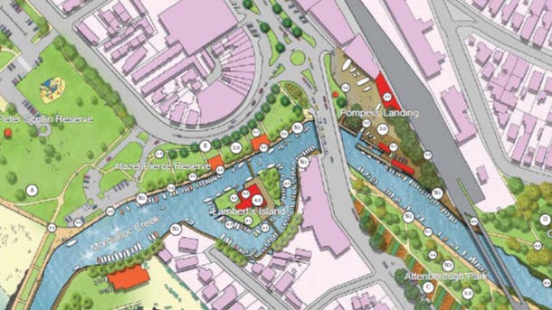
The Mordialloc Creek Masterplan outlines the vision for the Mordialloc Creek area over the next 20-30 years and identifies future projects to achieve this vision. The Masterplan specifically focuses on the land surrounding the creek including Peter Scullin Reserve, Hazel Pearce Reserve, Pompei’s Landing, Attenborough Park, George Woods Reserve and Lambert’s Island. It does not include the actual creek itself, or the dredging (which is a separate initiative).
How has the draft Masterplan been developed?
Development commenced in 2009 following a $250k grant from DSE. Council engaged a landscape-based consultancy Taylor Cullity Lethlean (TCL) to prepare a Draft Masterplan to create an integrated open space network and provide clarity on the different roles of each of the precincts.
A ‘Draft Concept Design Report’ was made available for consultation in April/May 2010. Based on community feedback, two of the original ideas, the Creek Link (new bridge near the creek mouth) and Intersection Improvement (signalising Beach Road and Main Street intersection) have been removed from the draft Masterplan. The remaining ideas have been further refined and developed into a draft Masterplan document.
The Draft Masterplan was available for community consultation in October/November 2011. Based on community feedback, Council adopted the Masterplan with a number of changes. These cover inclusion of the 4th Mordialloc Sea Scouts and the Mordialloc Life Saving Club; removal of the proposed new bridge to Lambert’s Island and proposed public access, as well as introducing palm trees along the Beach Road frontage of Hazel Pierce Reserve.
To view the pdf version of the masterplan click here
Further Information
For further assistance, call the Activity Centres team on 9581 4713.
The Mordialloc Creek Masterplan was adopted by Council on 26 March 2012. Council made a number of changes to the Draft Masterplan after over 180 community submissions were received on the proposed initiatives. In March 2012 the final Masterplan was released, however a revision was made in September 2012 to fully reflect the Council Resolution.
What will the Mordialloc Creek Masterplan do?
The Mordialloc Creek Masterplan outlines the vision for the Mordialloc Creek area over the next 20-30 years and identifies future projects to achieve this vision. The Masterplan specifically focuses on the land surrounding the creek including Peter Scullin Reserve, Hazel Pearce Reserve, Pompei’s Landing, Attenborough Park, George Woods Reserve and Lambert’s Island. It does not include the actual creek itself, or the dredging (which is a separate initiative).
How has the draft Masterplan been developed?
Development commenced in 2009 following a $250k grant from DSE. Council engaged a landscape-based consultancy Taylor Cullity Lethlean (TCL) to prepare a Draft Masterplan to create an integrated open space network and provide clarity on the different roles of each of the precincts.
A ‘Draft Concept Design Report’ was made available for consultation in April/May 2010. Based on community feedback, two of the original ideas, the Creek Link (new bridge near the creek mouth) and Intersection Improvement (signalising Beach Road and Main Street intersection) have been removed from the draft Masterplan. The remaining ideas have been further refined and developed into a draft Masterplan document.
The Draft Masterplan was available for community consultation in October/November 2011. Based on community feedback, Council adopted the Masterplan with a number of changes. These cover inclusion of the 4th Mordialloc Sea Scouts and the Mordialloc Life Saving Club; removal of the proposed new bridge to Lambert’s Island and proposed public access, as well as introducing palm trees along the Beach Road frontage of Hazel Pierce Reserve.
To view the pdf version of the masterplan click here
Further Information
For further assistance, call the Activity Centres team on 9581 4713.